Airport Information
Location
| FAA Identifier: | OEB |
| Lat/Long: | 41-56-00.4150N / 085-03-09.3060W |
| 41-56.006917N / 085-03.155100W | |
| 41.9334486 / -85.0525850 | |
| (estimated) | |
| Elevation: | 959 ft. / 292 m (estimated) |
| Variation: | 05W (2000) |
| From City: | 3 miles W of COLDWATER, MI |
| Zip code: | 49036 |
Airport Operations
| Airport Use: | Open to the public |
| Sectional Chart: | CHICAGO |
| Control Tower: | No |
| ARTCC: | CHICAGO CENTER |
| FSS: | LANSING FLIGHT SERVICE STATION |
| (1-866-879-4066) | |
| NOTAMs Facility: | OEB (NOTAM-D service available) |
| Attendance: | IREG |
| Wind Indicator: | Lighted |
| Segmented Circle: | Yes |
| Lights: | DUSK-DAWN |
| ACTVT MIRL RYS 04/22 & 07/25; REIL RY 24 – CTAF. | |
| Beacon: | White-Green (lighted land airport) |
Airport Communications
| CTAF/UNICOM: | 122.7 |
| WX AWOS-3: | 118.125 (517-279-1810) |
| KALAMAZOO APPROACH: | 121.2 |
| KALAMAZOO DEPARTURE: | 121.2 |
| WX AWOS-3 at ANQ (18 nm S): | 118.175 (260-668-5630) |
| WX AWOS-3P at IRS (19 nm SW): | 121.325 (269-659-8715) |
| WX AWOS-3P at RMY (20 nm N): | 120.025 (269-781-9070) |
• APCH/DEP SERVICE PROVIDED BY CHICAGO ARTCC ON 127.55/263.1
(GOSHEN RCAG) WHEN KALAMAZOO APCH CTL CLSD.
Nearby Radio Navigation Aids
| VOR radial/distance | VOR name | Freq | Var |
| LFDr244/15.0 | LITCHFIELD VOR/DME | 111.20 | 05W |
| BTLr161/24.3 | BATTLE CREEK VORTAC | 109.40 | 02W |
| AZOr130/28.8 | KALAMAZOO VOR/DME | 109.00 | 01W |
| JXNr239/32.9 | JACKSON VOR/DME | 109.60 | 05W |
| NDB name | Hdg/Dist | Freq | Var | ID | |
| ANGOLA | 010/17.7 | 347 | 05W | ANQ | .- -. –.- |
| STURGIS | 071/18.5 | 382 | 04W | IRS | .. .-. … |
| THREE RIVERS | 096/24.1 | 407 | 02W | HAI | …. .- .. |
| BRYAN | 320/37.8 | 260 | 04W | BYN | -… -.– -. |
Airport Services
| Fuel Available: | 100LL, JET-A |
| 24 HR SELF-SERVICE FUEL W/MAJOR CREDIT CARD. | |
| Parking: | hangars and tiedowns |
| Airframe Service: | MAJOR |
| Powerplant Service: | MAJOR |
| Bottled Oxygen: | NONE |

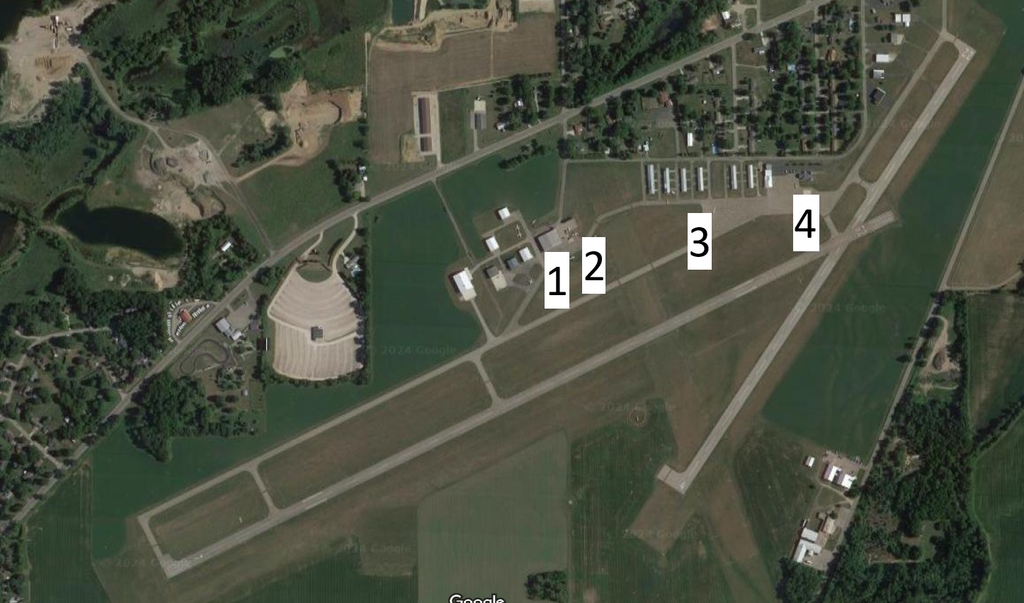
“KOEB” Branch County Coldwater Memorial Airport
1. Elite Maintenance Hangar
2. Self Serve Fuel Pumps
3. T Hangars for Rent
4. Branch County Airport Administration Building
RUNWAY INFORMATION
| RUNWAY 7/25 | |
| Dimensions: | 5350 x 75 ft. / 1631 x 23 m |
| Surface: | asphalt, in fair condition |
| Weight bearing capacity: | Single wheel: 20000 lbs |
| Runway edge lights: | medium intensity |
| RUNWAY 7 | RUNWAY 25 | |
| Latitude: | 41-55.772167N | 41-56.160400N |
| Longitude: | 085-03.847667W | 085-02.788700W |
| Elevation: | 956.0 ft. | 952.1 ft. |
| Traffic Pattern: | left | left |
| Runway Heading: | 069 magnetic, 064 true | 249 magnetic, 244 true |
| Markings: | nonprecision, in fair condition | nonprecision, in fair condition |
| Visual Slope Indicator: | 2-light PAPI on left (3.00 degrees glide path) | |
| Runway End Identifier Lights: | Yes | |
| REIL OTS INDEFLY. | ||
| Touchdown Point: | yes, no lights | yes, no lights |
| Obstructions: | 50 ft. trees, 1200 ft. from runway, | 15 ft. road, lighted, 380 ft. from runway, |
| 205 ft. left of centerline, 20:1 slope to clear |
277 ft. left of centerline, 12:1 slope to clear |
| RUNWAY 4/22 | |
| Dimensions: | 3500 x 75 ft. / 1067 x 23 m |
| Surface: | asphalt, in good condition |
| Weight bearing capacity: | Single wheel: 18000 lbs |
| Runway edge lights: | medium intensity |
| RUNWAY 4 | RUNWAY 22 | |
| Latitude: | 41-55.860650N | 41-56.341033N |
| Longitude: | 085-03.101650W | 085-02.675500W |
| Elevation: | 956.0 ft. | 955.0 ft. |
| Gradient: | 0.1 | 0.1 |
| Traffic Pattern: | left | left |
| Runway Heading: | 039 magnetic, 034 true | 219 magnetic, 214 true |
| Markings: | basic, in good condition | basic, in good condition |
| Runway End Identifier Lights: | no | no |
| Obstructions: | 53 ft. tree, 1260 ft. from runway, | 42 ft. tree, 1250 ft. from runway, |
| 50 ft. right of centerline, 20:1 slope to clear |
75 ft. right of centerline, 25:1 slope to clear |
| RUNWAY 16/34 | |
| Dimensions: | 2400 x 190 ft. / 732 x 58 m |
| Surface: | turf, in good condition |
| Runway Edge Markings: | RWY 16 DSPLCD THLD MKD WITH 3 FT YELLOW CONES. |
| RUNWAY 16 | RUNWAY34 | |
| Latitude: | 41-56.182517N | 41-55.806667N |
| Longitude: | 085-03.179817W | 085-03.016350W |
| Traffic Pattern: | left | left |
| Runway Heading: | 167 magnetic, 162 true | 347 magnetic, 342 true |
| Displaced Threshold: | 595 ft. | no |
| Runway End Identifier Lights: | no | no |
| Obstructions: | 52 ft. trees, 445 ft. from runway, | 44 ft. trees, 880 ft. from runway, |
| 30 ft. right of centerline, 8:1 slope to clear | 148 ft. right of centerline, 20:1 slope to clear | |
| RWY 16 APCH RATIO 20:1 AT DSPLCD THLD | ||
| OVER 52 FT TREES, 1040 FT DSTC, 30 FT R. |
AIRPORT OPERATIONAL STATISTICS
| Aircraft based on the field: | 33 | Aircraft operations: avg 38/day |
| Single engine airplanes: | 26 | 60% transient general aviation |
| Multi engine airplanes: | 2 | 40% local general aviation |
| Jet airplanes: | 2 | |
| Helicopters: | 2 | |
| Ultralights: | 1 |
ADDITIONAL REMARKS
– RYS 04/22 & 07/25 PLOWED WINTER MONTHS. CALL AMGR AT 517-279-7145 FOR CONDITIONS.
– FBO PHONE 517-278-6516.
– DEER ON & INVOF ARPT.
– GCO AVBL ON FREQ 121.725 THRU AZO CLEARANCE DELIVERY AND LAN AFSS.
